OFFICIAL SITE OF THE CAMPING GROUP www.grupabiwakowa.pl
STICKERS YOU CAN ORDER HERE https://www.facebook.com/groups/grupabiwakowa/search/
GROUP DESCRIPTION
The group is addressed to people who like to travel and camping in the wild.
You can exchange experiences, and share some cool places here. You will enjoy travel reports, tips and experiences on camping equipment , various patents and inventions to facilitate camping.
This is a group for people who enjoy spending time of the bosom of nature, enjoying an evening conversation by the fire, the taste of baked potatoes and sausages.
We do not accept advertising, spam, comments and political discussions, heats and attacks on other members of the group. Those who break the rules will also be removed from the group without notice.
By camping in the wild we mean sleepover in places other than camping – under the cloud, in a tent, car, caravan and camper.
Camping sites should be accessible without breaking the road rules and bans.
Presenters of the places and administrators of the group are not responsible for the validity of the data and the legality of the camping sites.
Places and directions must be assessed for the skills and the vehicle itself.
Remember that in such places we do not mess and do not destroy anything. We are also motivated to take away other trash if someone left it earlier. Let’s keep quiet. Let’s keep clean in the camp, rubbish immediately put in bags. We do not camp for weeks, because it can upset the land owners. The picnic areas are open for everybody and can not be blocked for a long of time. Often in their regulations there is that we can parked for up to 24 hours.
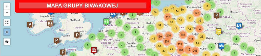
GROUP MAP
Google maps are created for all camping places. Access to the map is limited.Access to the map we receive by presenting at least 3 campsites or by show another helpful activity in the group.We do not want cool places to be public because people are very different. For some other time our campsites could be ruined and full of trash.When You will presenting campsites, give us directions, GPS coordinates(google), locations on the map.Provide information about the campsite, whether you can light a campfire, access to drinking water and other amenities.
On the map we only place the points and the photo of the campsite .Photos must be yours, or you must have permission to publish them in the group.By posting your photos of campsites in a group, You agree to their publication on Google Maps on the Groups page and on related mobile apps. Administrators are not responsible for your photos if they infringe someone’s copyright.
If you want to access to our map You need to have a google account. You must send a private message to the group’s administrator: www.facebook.com/iras72 ,Specify the number of places added and your email address associated with Google.
When you add an address to the map, you will receive a map link to your mailbox. The map is only visible when we are logged in to Google. Map points can be imported and uploaded to a GPS device (described later).
In addition to camping places on the map we also put places where we can get clean water, dump gray water and sewage.People who are not active and helpful will not have access to a camping site map. We will also not make maps available to group people who organize commercial travel.
REMARKS ON USING GROUP MAPS
Clicking on a selected camping location causes the left of the map to open the description of the place, a small photo and information about the number of photos from that place. By clicking on the picture, you can view it in full size and continue browsing the rest of the photos. You can also read GPS coordinates in the address bar.
We set up camping sites for GPS navigation in two stages. The first is to export data to the kmz file (compressed kml).
To the right of the map name on the red background are three dots. You have to click there and select „Download KML”. The „Export to KML” window will open. Click OK and save the kmz file containing all map data to disk. This file can be opened with Google Earth.At the end of the file should be </ kml> and there is sometimes only the opening bracket „<„. If there are problems, open the file editor and add at the end: / kml>
To insert these points for Garmin navigation, use the free BaseCamp program, which replaced the old Mapsource program. The kmz file can be imported to this program and sent directly to the connected device. This program can also export gpx data that can be inserted into other navigation or applications on the phone, such as OsmAnd (insert into the osmand \ tracks folder).